Mobility Update, 2025-10
There has been a lot happening on the mobility front, ranging from a plethora of bike land and trail projects to a new state budget (public transportation).
Bikes & Trails
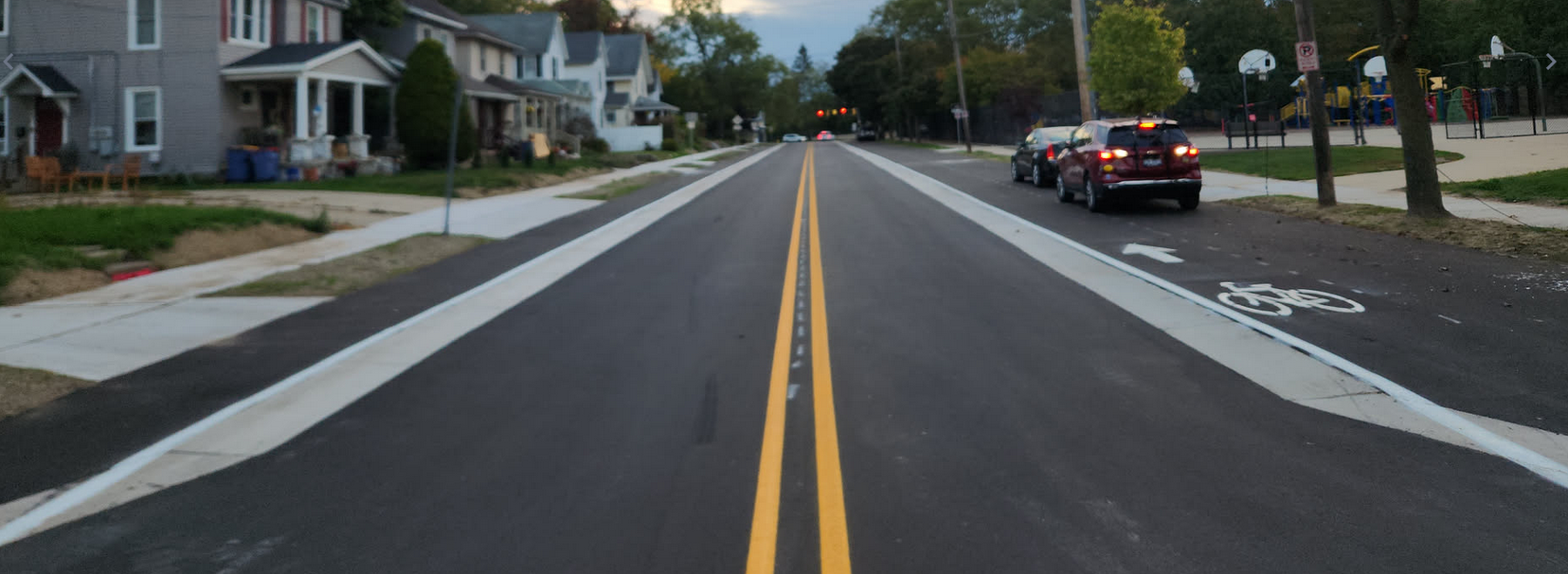
Ann St
The 2025 reconstruction of Ann St is complete; this added bike lanes to both sides of the road as well as reducing the grossly over-provisioned on-street parking by 50%. Now only the the south side of the road has on-street parking. The narrowing of the lanes - thanks to the bike lanes and curb extensions - should also reduce the reckless speeds of motorists, especially those exiting the interstate.
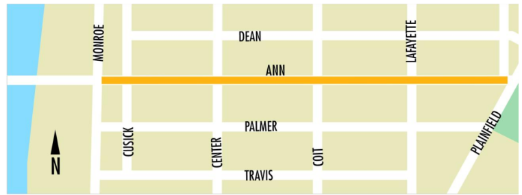
The completion of this project, as we've discussed before brings the possibility of a true bicycle network into view, but some emphasis needs to placed on closing the gaps which prevent realizing the full value of these investments. Most of this involves the bridge over the river and the intersections of Ann St with Turner Ave and the interstate.
It is notable that these gaps, all totaled, are only ~1.3 miles. The network is almost real.
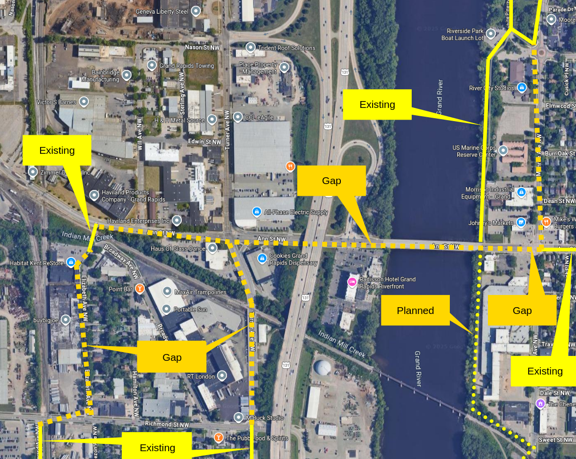
Rivers Edge
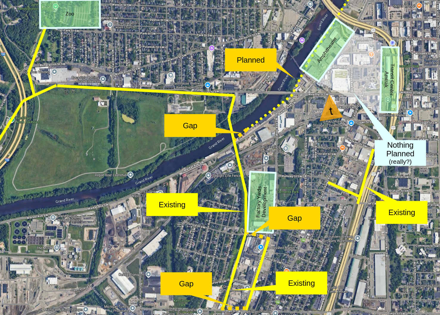
It is late 2025, and yes, we are still talking about the planning of the Grand River East / River's Edge trail.
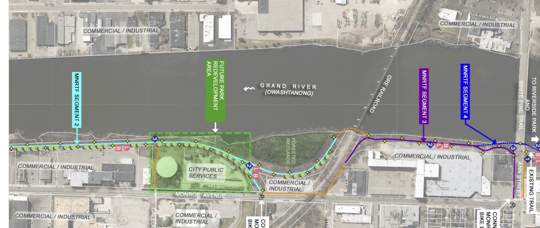
The last easement has been secured; it required purchasing the property at 1615 Monroe Ave NW. The railroad, which operates ~2 trains a day over river, told the project to go pound sand. So the trail will swing out to Monroe Ave, duck under the railroad's overpass, and then swing back to the river's edge. With this property secured, and thus the railroad out of the picture, the project should be going out to bid any day now. We'll see. Given this is ARPA funding which has a spend-by deadline in 2026 this is running very down to the wire.
How will this trail deal with cross Ann St and Leonard St? That has not been determined. Traffic Engineers have some concerns about "sight lines". The issue of the street crossings is likely to take a long time to resolve.
Aside: Traffic Engineers are not "engineers" in any meaningful sense. Becoming a Traffic Engineer is often little more than a four hour certification course. And yet this, essentially meaningless, title holds tremendous sway over the city's and the nation's infrastructure. Which might explain many things. The primary role of Traffic Engineers is to lobby on behalf of the status-quo, with the help of a job title to lend them credibility. Much like zoning their determinations are principally based on presupposition and status-quo bias; there is little to no science, data or expertise supporting the profession of "Traffic Engineer". You should feel no impulse to defer to them as having any intellectual clout due to their job title. Recommended reading: Confessions of a Recovering Engineer.
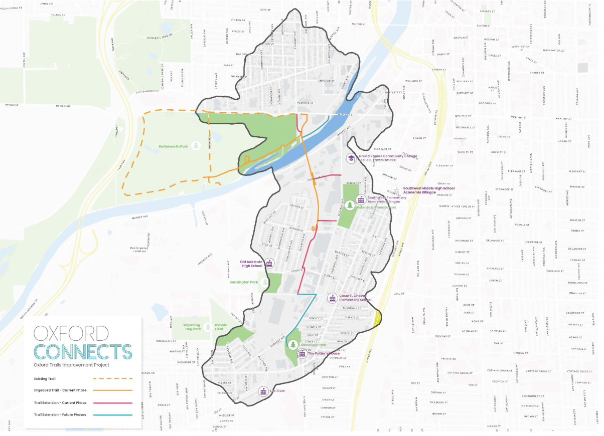
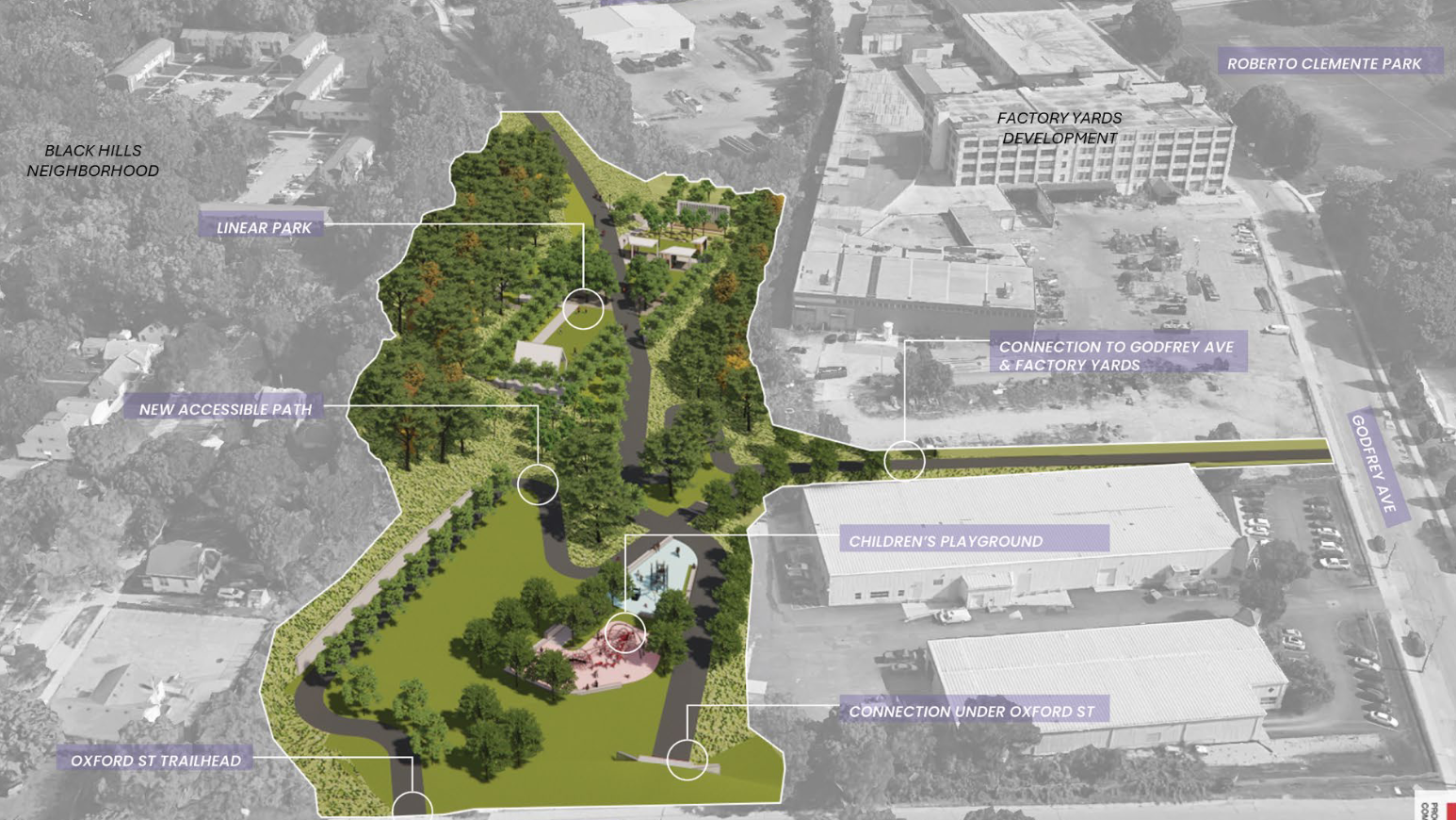
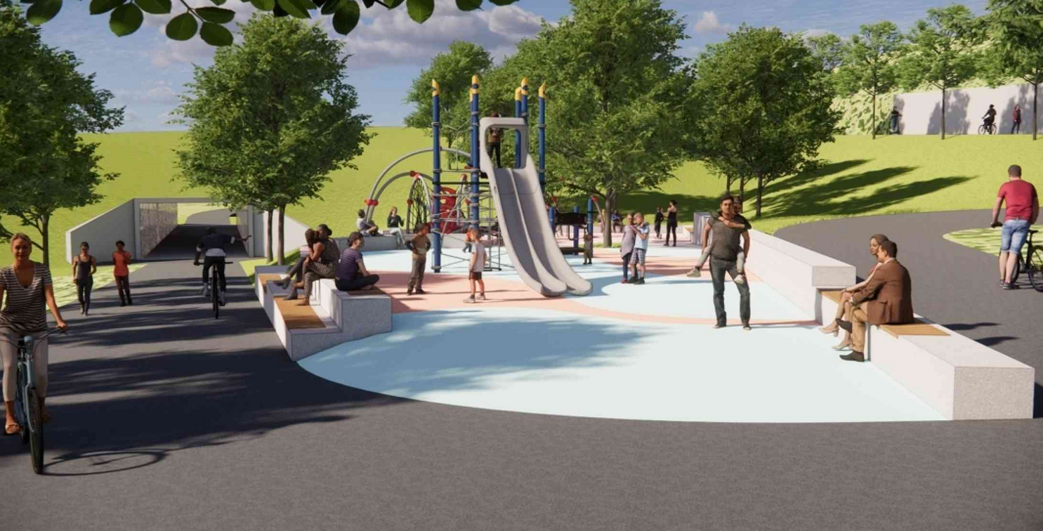
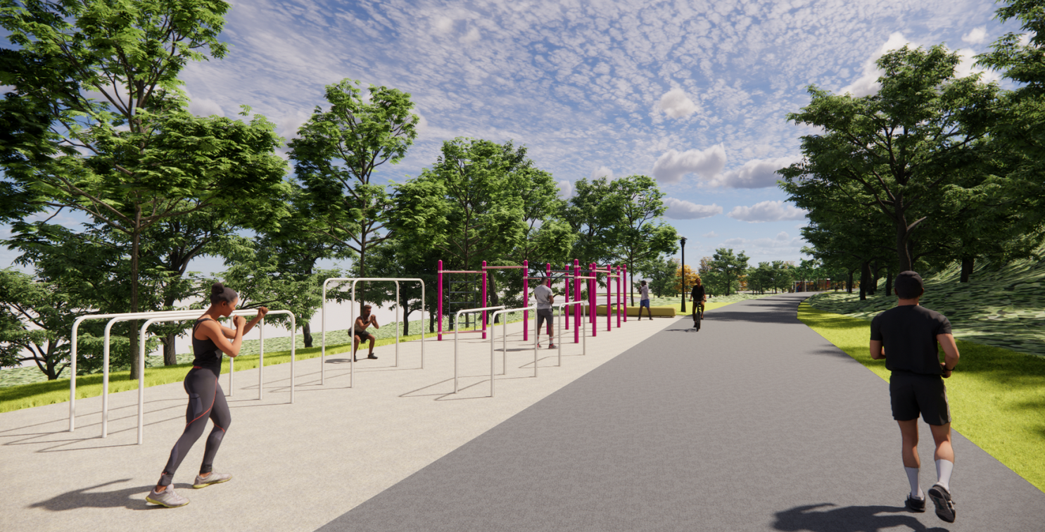
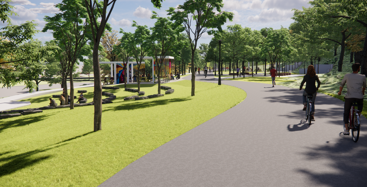
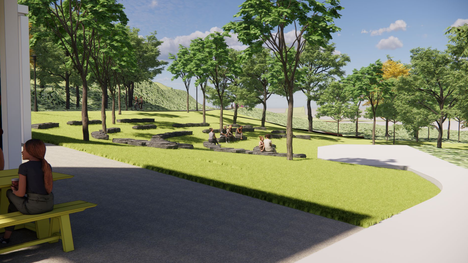
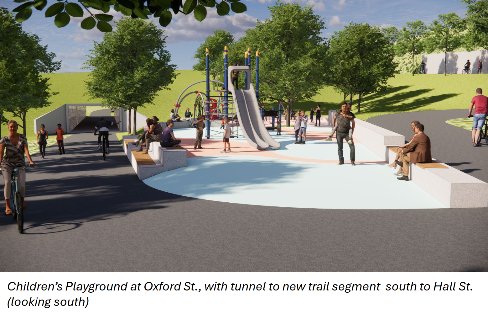
Oxford Trail
For years now the Oxford Trails has been a hidden gem, a fun extension of the Millennium Park and Butterwork Landfill trails, and a rare pedestrian and cyclist oriented river crossing. But now the contracts are out to realize its potential as a real infrastructure connecting the West Side and the Triangle district with all its venues and amenities to the Black Hills and Roosevelt Park neighborhoods. And at an opportune time as Godfrey Ave sees multiple developments and renovations bringing nearly five hundred (500) residential units to the corridor. The trail will soon connect from far-end of the West Side all the way to Hall St.
 |
 |
||||
 |
 |
 |
 |
 |
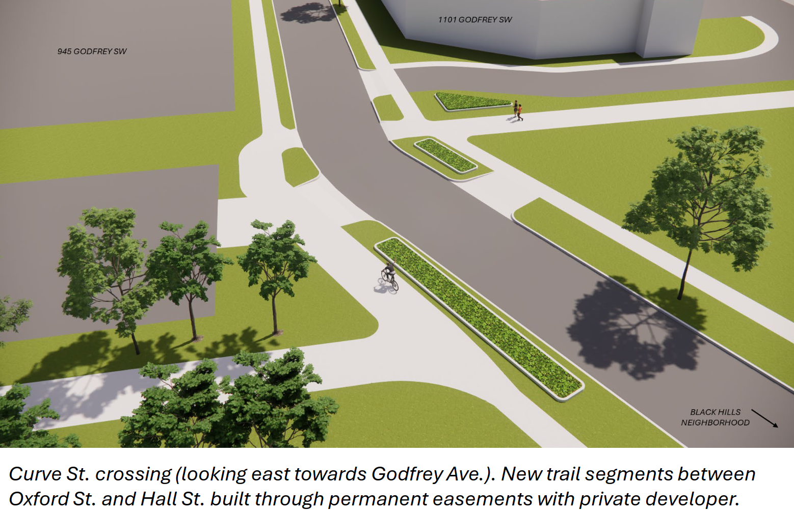 |
The extension of Oxford trail is a transformative project, by which we mean it has the potential to change the day-to-day lives of urban residents, far more so than the existence of an amphitheater or stadium. There is now a bicycle corridor that from somewhere to somewhere! This is the first of its kind in the city.
North - South
If all the planned - by which we mean that there is money in an account - bike lanes come to fruition the north-south access through the city center is also beginning to look like network although significant - and particularly challenging - gaps remain.
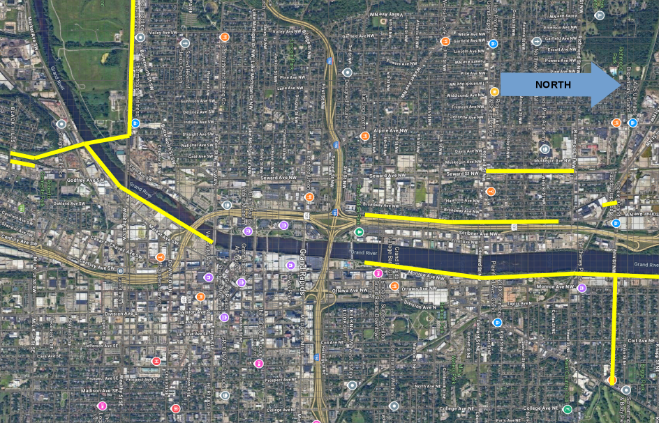
How to solve traversing north/south across the downtown core remains an unanswered question. At this point the best path for cyclists is likely to use the enhanced bike gutter on Division Ave south of Coldbrook St to Lyon St, and then the newly enhanced sidewalk of Division Ave to Monroe Center. The reconstruction of Division Ave from Lyon St to Fulton St which took place over the last two years was pitched as a bicycle through-way. Unfortunately it was value-engineered and tainted by the interference of MDOT into a little better than a wider but janky sidewalk. Then at Fulton a cyclist is dumped into what is little better than a wanna-be highway (Fulton St) with no clear next step in their route.
On the West Side there is tentative plans to extend the Turner Ave bike line south to Mt. Vernon Ave, and along the backside of the stadium (on Mt Vernon Ave) to Fulton. How serious those plans are is an open question. And still the question will be: what happens at Fulton St?
Wealthy St
Wealthy St is one of the most vibrant retail and neighborhood commercial corridors in the entire city, and Easttown has long been on of the most successful business districts. Eastown has also added significant residential density with the redevelopment of the Kingsley (1415 Lake Dr SE), the construction of Easttown Flats (1400 Wealthy St SE), and more on the way with the Robinson Road Flats (1407 Robinson Rd SE).
The Robsinson Road Flats development is an interesting case which demonstrates the shifting of the political winds. In the popular imagination's Scooby Doo narrative the evil real-estate developer knocks down buildings to build something new against the will of everyone else. But that is not what happened here. The Wheeler Development group proposed knocking down an adorable strip of street front retail buildings to build a three-story apartment building. And how did The People respond? The People said: "Can't you build more?" The Wheeler group, once they had collected their jaw off of the floor, went back to the drawing board and came back with a larger four-story mixed-use development with twenty-four (24) units. This sequence of events occurred because Easttown's leadership knows what Easttown is, Easttown is not a suburb, and Easttown is not Stars Hollow, Easttown is a walkable amentity-rich urban neighborhood.
Another upside of that self-knowledge is a group of neighbors who have been pushing the city to redesign Wealthy St to match what the entire eastern half of the Weatlhy St corridor is - which is an urban street. It should be designed accordingly, rather than as the particularly well dressed car-sewer it has been for the last several decades.
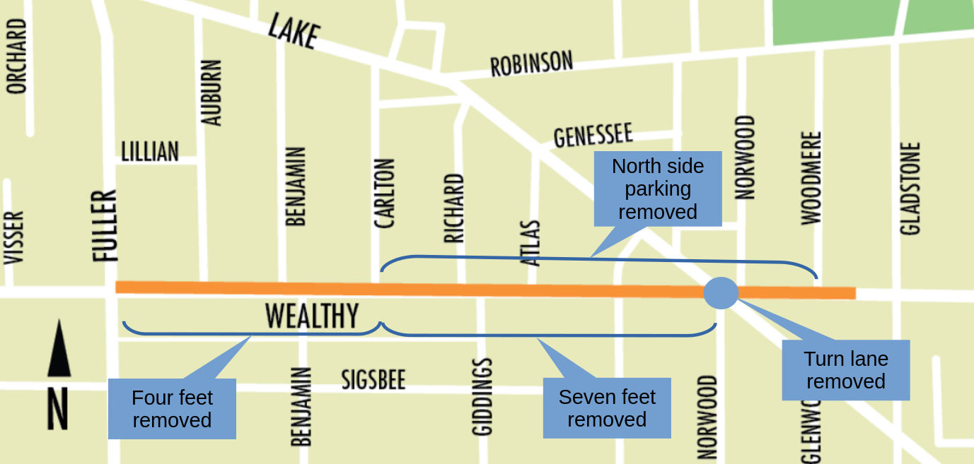
The street will be narrowed by four feet from Fuller Ave to Carlton Ave and by seven feet from Carlton Ave to Lake Drive. Narrowing the street slows traffic and makes space available for other, more productive, infrastructure including sidewalks and bike lanes. The dangerous right-turn lane on Wealthy St at Lake Drive will be removed as well as the street parking on the north side from Carlton Ave to Woodmere Ave.
This level of leadership bodes well for the continued prosperity of Easttown.
Of course, some business owners have come out in opposition. Being uninterested in the copious amounts of research, and likely oblivious to who their customers actually are, they fear the loss of business due to the loss of a dozen or so on-street parking spaces. They have also played the distasteful card small businesses always attempt use in parking discussions: "for individuals with disabilities, who will be forced to park further away". The one and only time they are concerned about accessibility.
Accessible crosswalks will be installed at all intersections, slower traffic and narrower streets are easier and safer to cross, wider well-maintained sidewalks are easier to navigate for those using mobility devices, and legally required disabled parking spaces will still be present (because they are legally required).
Recommended Reading
- A Case for Protected Bicycle Infrastructure on Wealthy Street, Strongtowns GR 2025-10
- What is the impact of bike lanes on local commerce?, 2025-01
- TL/DR: "contrary to business owners’ fears, bike lanes did not result in negative economic impacts"
- Understanding Economic and Business Impacts of Street Improvements for Bicycle and Mobility – AStreet Improvements for Bicycle and Mobility – A Multicity Multiapproach ExplorationMulticity Multiapproach Exploration, NITC 2020-04
- Bicycling Means Business: How Cycling Enriches People and Cities, 2013-03
- The Wealthy St Project Page, City of Grand Rapids
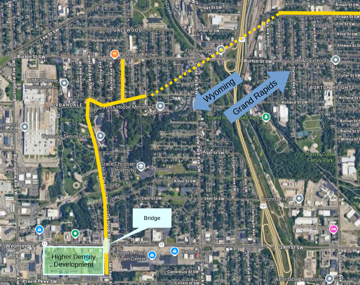
28th St Overpass
The city of Wyoming has its own trail and bike path network under development. Recently a significant part of that plan was installed: a pedestrian and cyclist bridge over 28th St connecting Pinery Park to the north with the higher density development zone established on the south side of the 28th. The HOM Flats development currently contains 386 rental units with phase three of the development underway which will add an addition two hundred (200) units. That will create a total of nearly six hundred (600) residential units. This makes HOM Flats one of the largest residential developments in the urbanized area. The pedestrian bridge will connect all of those citizens to the urban fabric; without having to risk their lives crossing MDOT's urban planning masterpiece (28th St),
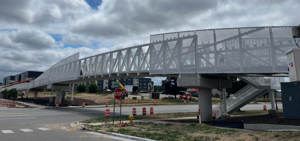
In relation to Grand Rapids residents the nearest connection will be to that of the Griggs St bike way discussed in the October 2024 mobility update. The Griggs St bike way runs from where Griggs ends at the railyards to the west to Breton Village Mall to the east.
Public Transportation
The State Budget
Somehow the state budget finally came through as a modest win for public transportation!
LBO (Local Bus Operating) came in at $271,000,000 which is an all time high for the state of Michigan [not factoring for inflation]. Due to some tedium in how the CTF (Comprehensive Transportation Fund) is calculated it is likely that the $271M will be a base amount with the potential for another $35M - $52M to arrive in the LBO line item, per year, between now and 2030. . . provided that the state legislature does not change the allocation formulas in the interim. I leave the probability of that happening as an exercise for the reader. If all goes well the LBO funding for 2026-2027 should be ~$300,000,000. 🤞 This is an increase of $44,000,000 over 2025-2026 [not adjusting for inflation].
Full funding of the CTF, as required by Act 51 of 1951, would require ~$450,000,000. This budget places us at 66% of full-funding for Michigan's transportation services. The word "required" here is an interesting one. It means what is required from what the state legislature appropriates. LBO operates as a match system, where the state matches 50% of an urban transportation authorities' operating expenses up until the LBO funds are exhausted. The state has never matched 50% of the Rapid's operating expenses as the legislature has never appropriated sufficient funds to do so. Whatever funds are appropriated are distributed between the state's eighty (80) transportation authorities.
Aside: Rural transportation authorities receive a larger match of 60% of their expenses.
MDOT's own calculation is that - with inflation factored in - Michigan's transportation services required $270,000,000 to continue operation as-is, at least as it relates to state funding. So the base funding of $271,000,000, while being an all time high, is a status-quo funding level. Do not get excited about the large numbers; great things are not going to happen. OTOH, any conversations about service cuts will be due to local funding issues.
Aside: How was this status-quo funding level not achievable during the Democratic Trifecta (2022 - 2024)? 😞 The far more generous legislative package on the floor in 2024 died in the dumpster fire at the end of the Democratic Trifecta when the party leaders could not get representatives to show up to vote. 😠
There is also $325,000,000 appropriated over the next five years available for transit infrastructure projects; assuming the legislature does not claw that funding back in future budgets. West Michigan will need to work diligently get a slice of that funding which will naturally flow to the east side of the state thanks to the dogged advocacy of organizations like TRU which have ensured that there are projects ready on the table. West Michigan's and Grand Rapids' leaders have neglected the public transportation discussion for the last decade and are starting this game with an empty hand, provided they are even interesting in playing.
Recommended Reading
- How Michigan Funds Local Public Transportation, StrongtownsGR 2023-12
- 103rd Legislature, March-October 2025: We (Finally) Have a Budget, The Cafe Car 2025-10
The Millage
The Rapid's quite paltry operating millage expires at the end of 2029, four years from now (2025). This is the Rapids' primary source of local funding. By Michigan law the Rapid - a public transportation authority - can only place a funding item on the ballot once a year. Meaning there are at most four opportunities to renew the existing millage or pursue a new increased millage.
The Rapid's leadership - which is a very generous description of the current board - has yet to lay out even the concept of a plan to maintain or enhance the Rapid. We, the citizens of Grand Rapids, would do well to have a plan in hand for the possibility of The Rapid failing as an institution and the ITP (The Rapids legal name) reaching a state were dissolution is an option on the table. Capturing the assets of the Rapid, particularly Rapid Central Station and the bus fleet, for utilization as the foundation of a new transportation agency which could focus on providing service for city residents. Shedding the suburban communities which no longer support the institution opens the possibility of significantly more robust service.
My understanding of the state legislation which enables the creation of transportation authorities requires that all assets owned by an authority, upon dissolution, must be transferred to another public institution. Perhaps the possibility exists for the creation of an initially empty / non-operational authority which could be standing by for possibility of the dissolution of the ITP?
Aside: From admittedly anecdotal conversations it does appear that the ludicrous notion of expanding The Rapids coverage area even farther - former Mayor Bliss' vision of county wide public transportation - has finally been accepted as a dead-end. You can view the Rapids' presentation in February of 2024 to the County Commission 🎥here🎥 to witness for yourself the county's overwhelming disinterest in the notion of expanding public transportation services.
Recommended Reading
- The Local Transit Senate, UrbanGR 2023-09
- The Beginning Of The End (of The Rapid)?, UrbanGR 2023-12
- Voter Support Of the RAPID in 2017, UrbanGR 2018-02
The DASH
The DASH continues to crush ridership numbers . . .
| Metric | August 2024 | August 2025 | Change |
|---|---|---|---|
| Riders | 36,064 | 43,931 | +22% |
| Passengers per Hour | 13.8 | 16.7 | +21% |
| Passengers per Mile | 1.4 | 1.7 | +21% |
Meanwhile there are multiple conversations occurring about the future of The DASH system, both the primary circulator route and the less prominant Work route. There are quantifiable issues of on-time performance due to both operator shortages and bus bunching and that the city is underpaying The Rapid for operation of the service. And there are other issues which the October meeting of the MobileGR Commission spent a significant amount of time dancing around. 🎥youtube🎥 Nobody at the meeting wanted to say that the primary issue being discussed was that the unhoused and other categories of poors are significant users of the DASH; something which conflicts with downtown's brand. It was a frustrating conversation to listen to.
As with the Amphitheater and Stadium being promoted as "transformative" projects much of the cities leadership is clinging to a perspective that downtown and its amenities are for visitors rather than downtown being a commercial, service, and entertainment nexus for residents of the city.
If the DASH is important to you it is advisable to really stay tuned in the coming months. Decisions are being made without any clear process for how those decisions will be made.
Safety
So far this year- meaning through the end of August - there has been an overall decline in accidents involving pedestrians, micromobility (including cyclists) , and even motorists. There has been a total of 3 fatalities and 167 injuries across all modes in 2025, comparted to totals of 7 fatalities and 238 injuries in 2024. At least in part this is likely due the continuing decline in traffic on Grand Rapids' streets.
As documented in the May 2025 mobility update the safest, by far, form of mobility is public transportation (the Rapid). Riding a Rapid bus is 2,200% safer than riding in or driving a private motor vehicle; that is not a typo, yes, it is 22X safer per mile. Any perception that there is a safety issue related to public transportation is completely unmoored from reality.
Pedestrians
| Strata | YTD 2024 | YTD 2025 | Delta |
|---|---|---|---|
| Fatality | 1 | 0 | -100% |
| Serious Injury | 14 | 10 | -28% |
| Minor Injury | 17 | 12 | -29% |
| Possible Minor Injury | 24 | 17 | -29% |
| Property Only | 10 | 8 | -20% |
Micromobility
This category includes cyclists, and both shared and non-shared micromobility devices [private scooters as well as LIME scooters, etc...].
| Strata | YTD 2024 | YTD 2025 | Delta |
|---|---|---|---|
| Fatality | 1 | 0 | -100% |
| Serious Injury | 7 | 7 | ~ |
| Minor Injury | 22 | 19 | -13% |
| Possible Minor Injury | 19 | 30 | +57% |
| Property Only | 15 | 8 | -46% |
Motorists
| Strata | YTD 2024 | YTD 2025 | Delta |
|---|---|---|---|
| Fatality | 5 | 3 | -40% |
| Serious Injury | 41 | 32 | -22% |
| Minor Injury | 137 | 87 | -36% |
| Possible Minor Injury | 285 | 226 | -21% |
| Property Only | 1597 | 1274 | -20% |